TENNESSEE GEOGRAPHIC ALLIANCE
  • Home
    • Join the TGA
    • TGA Membership Dashboard
    • Geography and GIS Programs in Tennessee
    • Upcoming Events
  • Resources
    • Discovery Park: Maps and Globes Workshop
    • Drawing Worlds
    • Tennessee Giant Map >
      • TN Giant Map Lessons and Activities
      • Next Steps
    • 2021 TCSS Geography Night, Tuesday 2/23
    • 2020 TCSS Geography Strand, Saturday 2/23
    • AP Human Geography
    • Archived Workshop Resources
    • Bell Ringers
    • Geographic Links
    • Geography Resources
    • Lesson Plans
  • Special Interests
    • Southern Foodways
    • Monthly Observances >
      • African American Heritage (February)
      • Women's (March)
      • Irish-American (March)
      • Asian Pacific American (May)
      • Hispanic Heritage (September 15 to October 15)
      • Native American Heritage (November) >
        • Regarding Thanksgiving
    • National Weather Service Resources
  • Geographic Information Systems (GIS)
    • What is GIS?
    • Tennessee ArcGIS Online Map Contest
    • TGA Open Data Portal
    • K-5 Focus >
      • STEAM at Work! (Lindsey the GIS Professional!)
      • National Geographic’s MapMaker
    • Geospatial Revolution Project
    • Google Earth/Map Resources >
      • National Geographic's Google Earth Resources
      • Visualize your data on a custom map using Google My Maps (Tutorial)
      • Create a map or story in Google Earth Web (Tutorial)
      • How to Create a Geographical Map Chart in Google Sheets
    • Getting to Know GeoInquiries >
      • GeoInquiries (Teacher Worksheets)
      • GeoInquiries (Student Worksheets)
    • ArcGIS Online (Esri) Resources >
      • Get Started with ArcGIS Online
      • Teach with GIS (Esri Lessons)
      • ArcGIS StoryMaps
      • ArcGIS Survey123
    • GIS in CTE >
      • Career and Technical Education Instructors
      • Getting to Know GIS in CTE
      • Explore Careers in GIS (Virtual Job Shadow)
Picture

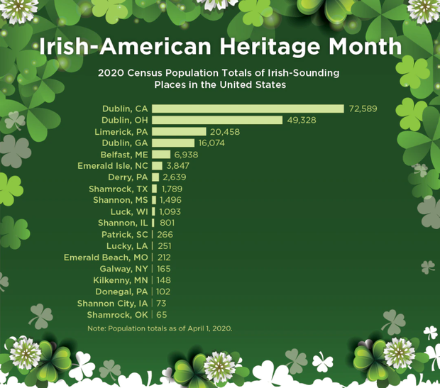
Irish-American Heritage Month

Congress designated March as Irish-American Heritage Month in 1991 and the president issues a proclamation every year. 7th grade social studies teachers often use St. Patrick to discuss the following standard (7.28): Describe the role of monasteries in the preservation of knowledge and spread of the Catholic Church beyond the Alps. Check out resources related to this at:
  • Library of Congress
  • U.S. Census Bureau
  • National Geographic Kids: St. Patrick's Day
  • National Geographic: Who was Saint Patrick and why does he have a day?
st.patricks-day-fast_facts__1_.pdf
File Size: 429 kb
File Type: pdf
Download File

st.patricks-day-fast_facts_teachers_guide.pdf
File Size: 255 kb
File Type: pdf
Download File

Proudly powered by Weebly
  • Home
    • Join the TGA
    • TGA Membership Dashboard
    • Geography and GIS Programs in Tennessee
    • Upcoming Events
  • Resources
    • Discovery Park: Maps and Globes Workshop
    • Drawing Worlds
    • Tennessee Giant Map >
      • TN Giant Map Lessons and Activities
      • Next Steps
    • 2021 TCSS Geography Night, Tuesday 2/23
    • 2020 TCSS Geography Strand, Saturday 2/23
    • AP Human Geography
    • Archived Workshop Resources
    • Bell Ringers
    • Geographic Links
    • Geography Resources
    • Lesson Plans
  • Special Interests
    • Southern Foodways
    • Monthly Observances >
      • African American Heritage (February)
      • Women's (March)
      • Irish-American (March)
      • Asian Pacific American (May)
      • Hispanic Heritage (September 15 to October 15)
      • Native American Heritage (November) >
        • Regarding Thanksgiving
    • National Weather Service Resources
  • Geographic Information Systems (GIS)
    • What is GIS?
    • Tennessee ArcGIS Online Map Contest
    • TGA Open Data Portal
    • K-5 Focus >
      • STEAM at Work! (Lindsey the GIS Professional!)
      • National Geographic’s MapMaker
    • Geospatial Revolution Project
    • Google Earth/Map Resources >
      • National Geographic's Google Earth Resources
      • Visualize your data on a custom map using Google My Maps (Tutorial)
      • Create a map or story in Google Earth Web (Tutorial)
      • How to Create a Geographical Map Chart in Google Sheets
    • Getting to Know GeoInquiries >
      • GeoInquiries (Teacher Worksheets)
      • GeoInquiries (Student Worksheets)
    • ArcGIS Online (Esri) Resources >
      • Get Started with ArcGIS Online
      • Teach with GIS (Esri Lessons)
      • ArcGIS StoryMaps
      • ArcGIS Survey123
    • GIS in CTE >
      • Career and Technical Education Instructors
      • Getting to Know GIS in CTE
      • Explore Careers in GIS (Virtual Job Shadow)