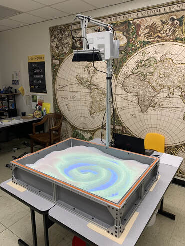
TENNESSEE GEOGRAPHIC ALLIANCE
  • Home
    • Awards and Contest >
      • AAE’s National Scholarship & Grant Program
      • AGS Geoboost: Opens in the Fall
      • AGS Teacher Fellows
      • Fund for Teachers: $5K to develop your own PD!
      • GTOY Awards
      • Grosvenor Teacher Fellowship (GTF)
      • TGA Geography Mini-Grants
      • Online Student Mapping Contest
      • Slingshot Challenges
    • Geography and GIS Programs in Tennessee
    • Join the TGA
    • Not getting the newsletter?
    • Sign up for 'Daily Geo': Today's News with a Geographical Twist
    • TGA Membership Dashboard
    • Upcoming Events
  • Resources
    • A Special Look
    • Geography Games >
      • GeoGuessr
      • Globle
      • Worldle
    • Geography is Everywhere! >
      • Art and Geography
      • ELA and Geography
      • Math and Geography
      • Monthly Observances >
        • African American Heritage (February)
        • Women's (March)
        • Irish-American (March)
        • Asian Pacific American (May)
        • Hispanic Heritage (September 15 to October 15)
        • Native American Heritage (November)
        • Regarding Thanksgiving
      • Science and Geography >
        • National Weather Service Resources
      • Southern Foodways
    • Historical Maps
    • Lesson Plans
    • Tennessee Giant Map
    • Tennessee State Portfoliio (External Link)
    • What's in a Name? >
      • What's in a Name? Story Maps
      • What's in a Name? Asynchronious Video Experience
    • World Historical Gazetteer (External Link)
    • Archived Workshop Resources
  • APHG
    • American Geographical Society's (FREE) Blog Ubique
    • APHG: The Exam
    • Bell Ringers
    • Geography Resources
    • iScore5, the APHG Ap (paid)
    • NCGE's APHG Resources
  • GIS
    • GIS in the Early Elementary Classroom
    • GIS in Upper Elementary Classroom
    • GIS in Middle School STEM Classes
    • Introduction to GIS (High School Course)
    • GIS in the APHG Classroom!
  • Donate to the TGA!

Augmented Reality Sandbox (ARS)

Spatial thinking often challenges students. That is why the TGA partnered with UTK's GIS Outreach and Engagement Lab to demonstrate how an ARS can be a powerful tool to bridge the gap between two-dimensional (2D) representations and real landscapes, as well as enhancing the spatial thinking and modeling abilities of students.
Below are
 classroom lessons on how to develop spatial thinking using contour lines, topographic maps, and play-dough (for those not able to access the ARS).
using_contours_to_determine_elevation.pdf
File Size: 411 kb
File Type: pdf
Download File

usgs_ars_lessons.pdf
File Size: 258 kb
File Type: pdf
Download File

play-dough_topo.pdf
File Size: 3146 kb
File Type: pdf
Download File

Picture
For directions on building your own ARS, click HERE.
On building "a more perfect sandbox", click HERE.
Proudly powered by Weebly
  • Home
    • Awards and Contest >
      • AAE’s National Scholarship & Grant Program
      • AGS Geoboost: Opens in the Fall
      • AGS Teacher Fellows
      • Fund for Teachers: $5K to develop your own PD!
      • GTOY Awards
      • Grosvenor Teacher Fellowship (GTF)
      • TGA Geography Mini-Grants
      • Online Student Mapping Contest
      • Slingshot Challenges
    • Geography and GIS Programs in Tennessee
    • Join the TGA
    • Not getting the newsletter?
    • Sign up for 'Daily Geo': Today's News with a Geographical Twist
    • TGA Membership Dashboard
    • Upcoming Events
  • Resources
    • A Special Look
    • Geography Games >
      • GeoGuessr
      • Globle
      • Worldle
    • Geography is Everywhere! >
      • Art and Geography
      • ELA and Geography
      • Math and Geography
      • Monthly Observances >
        • African American Heritage (February)
        • Women's (March)
        • Irish-American (March)
        • Asian Pacific American (May)
        • Hispanic Heritage (September 15 to October 15)
        • Native American Heritage (November)
        • Regarding Thanksgiving
      • Science and Geography >
        • National Weather Service Resources
      • Southern Foodways
    • Historical Maps
    • Lesson Plans
    • Tennessee Giant Map
    • Tennessee State Portfoliio (External Link)
    • What's in a Name? >
      • What's in a Name? Story Maps
      • What's in a Name? Asynchronious Video Experience
    • World Historical Gazetteer (External Link)
    • Archived Workshop Resources
  • APHG
    • American Geographical Society's (FREE) Blog Ubique
    • APHG: The Exam
    • Bell Ringers
    • Geography Resources
    • iScore5, the APHG Ap (paid)
    • NCGE's APHG Resources
  • GIS
    • GIS in the Early Elementary Classroom
    • GIS in Upper Elementary Classroom
    • GIS in Middle School STEM Classes
    • Introduction to GIS (High School Course)
    • GIS in the APHG Classroom!
  • Donate to the TGA!